Here’s how Charlotte’s Strategic Mobility Plan improves transit for rail and bus riders
Charlotte City Council is set to vote on the Strategic Mobility Plan on Mondy, June 27. We support the plan and consider it a crucial step in creating safe and equitable mobility choices for everyone in our city.
This is Part 2 in a series highlighting how the Strategic Mobility Plan will impact your experience here in Charlotte. Here is how your experience might change if you are a transit rider.
You can read Part 1 — all about cycling — right here.
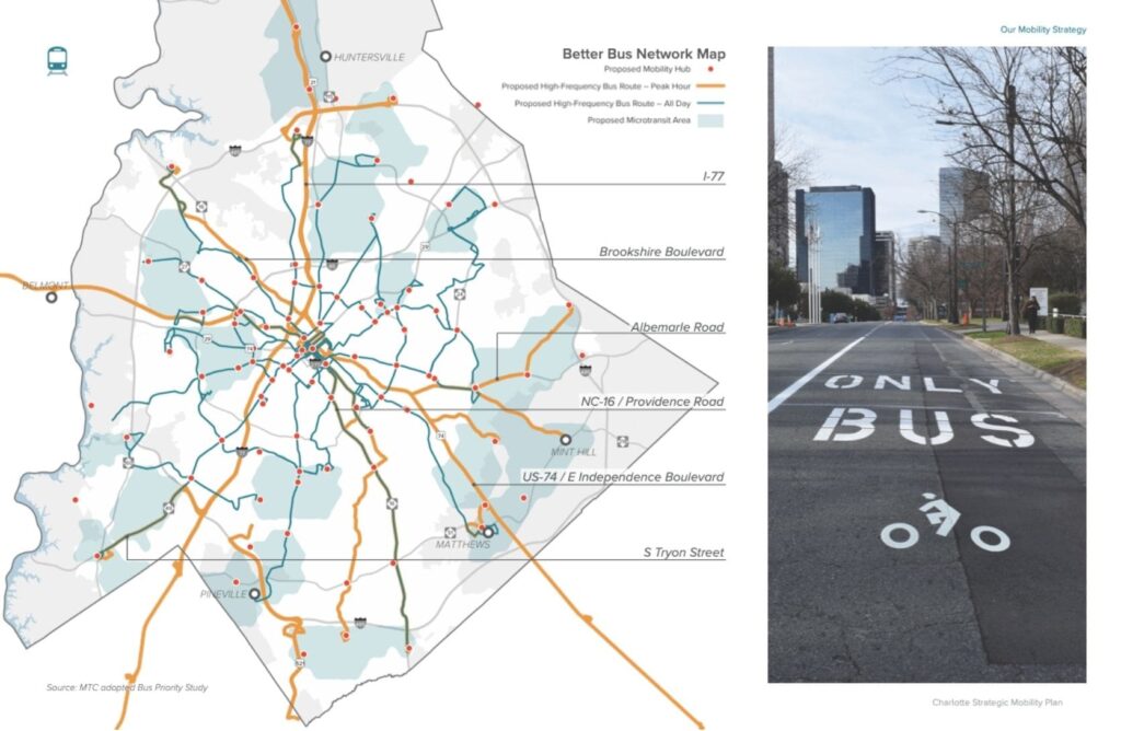
Imagine only waiting 15 minutes for a bus in charlotte
The Strategic Mobility Plan would serve 390 miles of bus routes at a “high-frequency” rate, meaning that the buses (except Express routes) would run every 15 minutes or less. In addition, the Charlotte Department of Transportation, Charlotte Area Transit System, the Metropolitan Transit Commission, and the Charlotte Regional Transportation Coalition have all coordinated to service a total of 643 miles of routes during peak hours, meaning commuters from the suburbs and exurbs of the city can also enjoy quick trips and short wait times.
This higher frequency would ensure that bus riders will never have to wait longer than 15 minutes to be on their way, giving riders greater flexibility in their personal schedules and allowing for personal errors (such as stepping on the wrong bus) to be more forgiving since another bus will be just around the corner. When buses come by every 15 minutes, transfers between routes also become much more time-efficient for riders.
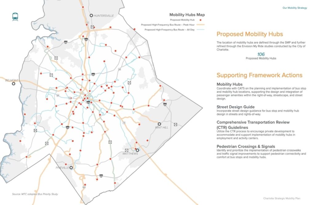
Charlotte’s transit network would broaden its focus
The current hub-and-spoke model that CATS operates on — with most routes winding up at the Charlotte Transit Center in uptown — simply does not work for many riders. As part of the Envision My Ride bus priority initiative, CATS made significant structural changes to the bus network in 2018 to improve crosstown connectivity and overall travel times. But there is still a need to optimize routes to best meet riders’ needs.
Under the Strategic Mobility Plan’s guidelines, CATS would transition to mobility hubs throughout Charlotte. These hubs would serve as defined centers that support many types of transportation options, such as walking, biking, and even microtransit. In short, it would become easier to make cross-county trips. For example, riders would be able to go from the Eastland Community Transit Center in east Charlotte to University City in northeast Charlotte and then to Pineville south of the city.
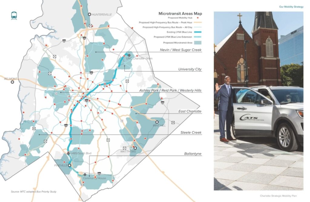
Charlotte could use microtransit to make commutes easier
Have you ever stepped onto a CATS bus only to find yourself the only person on it for miles? Would you use the nearest transit line but don’t because it’s a 2-mile walk away? With the new microtransit plan, both of these issues would be resolved. Using smaller shuttle vehicles, the microtransit project would service less-populated areas of Charlotte and also help resolve the first-mile/last-mile problem that many transit users experience.
This microtransit option would operate in two ways. First, the smaller vehicle would replace larger buses in less-populated regions, keeping operational costs lower while ensuring service is frequent. Second, the shuttle would operate on-demand much like a rideshare service, such as Uber or Lyft. Users would request a ride from the shuttle, then they would be picked up and efficiently ferried to a transit hub where they can connect to the next leg of their trip.
The best part about the on-demand service? No surge pricing.
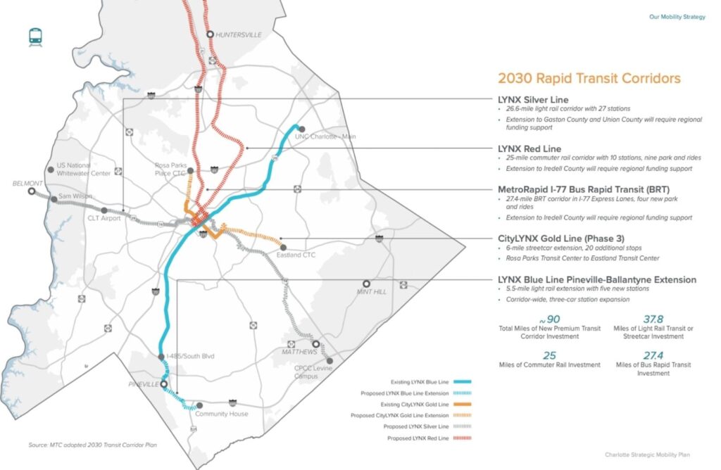
Charlotte’s rail system would get bigger
The LYNX light rail lines that many Charlotteans love would be further expanded. The Silver Line would run east to west across Charlotte, and the Red Line would connect uptown to northern Mecklenburg County. The existing Blue Line would be extended, along with the route for the CityLYNX Gold Line streetcar. This series of projects would expand service to Pineville, Ballantyne, the Eastland CTC, Matthews, Charlotte Douglas International Airport, the Rosa Parks Place CTC, and Huntersville. All of these areas will be serviced with just 65 miles of track.
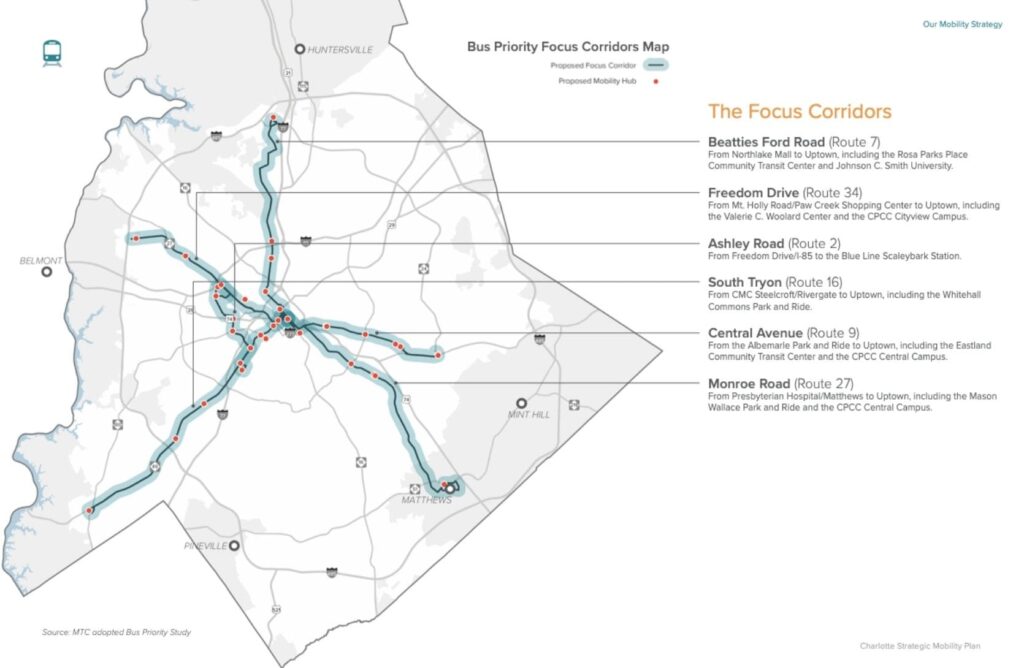
Charlotte’s bus system would get better
Who doesn’t love a great and functional bus system? With the Strategic Mobility Plan, the city would target six priority corridors where CATS buses would be able to bypass traffic. These corridors would be Beatties Ford Road, Freedom Drive, Ashley Road, South Tryon, Central Avenue, and Monroe Road. This would be accomplished in three main ways: transit signal priority, which would detect when a bus is coming and give it a green light; intersection queue jumps, which would allow a bus to skip past a line of cars at a stop light; and dedicated bus lanes that would let buses move faster.
How to voice your support for the Strategic Mobility Plan
Charlotte City Council will vote June 27 on adopting the Strategic Mobility Plan. There’s still time for you to weigh in. Here’s an easy way to contact your representatives and let them know you support the Strategic Mobility Plan!
Thanks for reading!
As a nonprofit, community support is essential for us to keep doing what we do — including providing free articles like this. If you found this article helpful, please consider supporting Sustain Charlotte.
Want to stay in the loop? Subscribe to our weekly newsletter and follow us on Instagram, Facebook, and Twitter.